Thursday, December 29, 2011

An 1816 Matron Head large cent, Pierre L'Enfant, and the platting of Perrysburg, Ohio


I inadvertently skipped the year 1816 in my last posting showing an early U.S. coin matched with Northwest Ohio history.  So now, I'm posting a photo of a large cent from 1816.  This is the first year that this particular design appeared, and it is often referred to as the "Matron Head" large cent, since Lady Liberty looks a bit older and more matronly on this issue than on  previous types of large cents.  This coin is not perfect and has some minor patches of verdigris (light mineralization or corrosion in the copper) on the reverse, but it has some really nice eye appeal in its totally original (never cleaned) appearance and its dark mahogany and lighter reddish copper coloration... almost a "black and tan" two-tone look.  In the opinions of many early copper collectors, this look is very desirable, but of course this is subjective.  Matron Head large cents are historical, fun, and easy to collect due to their relative abundance and cheap prices, especially in lower grade conditions.
1816 Matron Head Large Cent obverse

1816 Matron Head Large Cent reverse

Plat of Perrysburg, Ohio, April 26, 1816
An interesting tie-in of this coin's year, 1816, to the Great Black Swamp region, is the platting of the town of Perrysburg, Ohio, by Pierre Charles L'Enfant.  In May and August of 1813, General William Henry Harrison held off the British and their Indian allies in two separate sieges of Fort Meigs, which is located just a few miles from present day Perrysburg.   In 1816, the U.S. government sent Pierre L'Enfant, the French-born American architect, civil engineer, and Revolutionary War combat veteran best known for designing the layout of the streets of Washington, D.C., to plat (lay out) the town of Perrysburg, Ohio.  Perrysburg was therefore only the only town other than Washington, D.C. so created in the United States.  It was named in honor of Commodore Oliver Hazard Perry, who led an American naval force to victory over the British in 1813 in the Battle of Lake Erie near Put-in-Bay.

With the opening of the Northwest Territory to settlers, many settlers passed through the area around Perrysburg, crossing the Maumee river at the first opportunity upstream from Lake Erie, the ford at the Foot of the Rapids, and continuing their journeys north or west into the newly acquired lands of the expanding United States.  Since Perrysburg was located on the northern rim of the Great Black Swamp, which was nearly impassable until the swamp had been largely drained in the late 1800's, early transportation into and out of Perrysburg was essentially restricted to the Maumee River.  In time Perrysburg became a major lake port and shipbuilding center—second only to Cleveland and Buffalo in goods shipped.  As the Great Black Swamp was very gradually drained, huge forests of virgin timber became available and untold millions of board feet of logs and lumber sawed in Perrysburg were floated or shipped down river, across the lake and on to domestic and foreign markets. 

Wednesday, December 21, 2011

An 1817/3 capped bust half dollar and the Treaty of the Rapids of the Miami of Lake Erie (Maumee)

I've been posting a number of articles on the Philippines lately, so I wanted to intersperse a post of another early U.S. coin paired with a specific event from U.S. history within or near the Great Black Swamp region.   This time I'm featuring an 1817/3 capped bust half dollar, Overton variety number O-101.   As you can see very clearly from the photo, there is a 3 beneath the 7 of the date.   This is referred to as an overdate, and this occurred at the mint when the obverse (front) die was being prepared.  Apparently due to materiel shortages and economic hardship that extended well after the War of 1812 ended (only a few half dollars were minted in 1815 and none were minted in 1816), there was a need to "recycle" one of the working dies from 1813, so in the year 1817 the mint worker punched a number 7 right on top of the old die from 1813.  One might consider this an error of omission, since the mint worker made no attempt to remove the underlying 3. The 1817/3 overdate is pretty scarce to come by in excellent condition, and is a variety that is represented in the Red Book guide to American coins, so it is in high demand from collectors.   Note that not all of the 1817 half dollars have this 7 over 3 overdate variety, but only a relatively small number in comparison to the remainder of non-overdate varieties of half dollars minted in 1817.

1817/3 O-101 Capped Bust Half Dollar obverse

1817/3 O-101 Capped Bust Half Dollar reverse

One of the tie-ins of this coin to contemporaneous Great Black Swamp area history is that on September 29, 1817, the Treaty of the Rapids of the Miami of Lake Erie (the Miami of Lake Erie is presently known as the Maumee River) was signed, at Fort Meigs in Maumee, Ohio. In this treaty the Wyandot Indians, the Seneca Indians, the Delaware Indians, the Shawnee Indians, the Potawatomi Indians, the Ottawa Indians, and the Chippewa Indians relinquished their claim to four million acres of land in northwestern Ohio. This treaty was also known as the Treaty with the Wyandot and the Fort Meigs Treaty.

The U.S. government agreed to pay $4,000 each year to the Wyandots, $500 a year to the Seneca tribe, and $2,000 dollars a year to the Shawnees. The United States also agreed to pay $1,300 a year for fifteen years to the Potawatomis, $1,000 a year for fifteen years each to the Ottawa and Chippewa tribes, and a single payment of $500 to the Delaware. In addition, some tribes received additional cash payments for damages they suffered during the War of 1812 because they were allies of the United States. The United States agreed to "grant land" to the various tribes as well... in other words, putting these Indian tribes on reservations. The Wyandots received a twelve-mile-square reservation at Upper Sandusky, Ohio. The Senecas received thirty thousand acres along the Sandusky River. The Shawnees received a ten-mile-square reservation at Wapakoneta in addition to several other grants. The Ottawas received a small parcel along the Auglaize River, while the Delawares were allotted a nine-mile-square reservation next to the Wyandots' land. As specified in Article 2 of the treaty:
'Article 2:  It is also agreed that there shall be reserved for the use of the Wyandots, in addition to the reservations before made, fifty-five thousand six hundred and eighty acres of land, to be laid off in two tracts, the first to adjoin the south line of the section of six hundred and forty acres of land heretofore reserved for the Wyandot chief, the Cherokee Boy, and to extend south to the north line of the reserve of twelve miles square, at Upper Sandusky, and the other to adjoin the east line of the reserve of twelve miles square, at Upper Sandusky, and to extend east for quantity.  
There shall also be reserved, for the use of the Wyandots residing at Solomon's town, and on Blanchard's fork, in addition to the reservations before made, sixteen thousand acres of land, to be laid off in a square form, on the head of Blanchard's fork, the centre of which shall be at the Big Spring, on the trace leading from Upper Sandusky to fort Findlay; and one hundred and sixty acres of land, for the use of the Wyandots, on the west side of the Sandusky river, adjoining the said river, and the lower line of two sections of land, agreed, by the treaty to which this is supplementary, to be granted to Elizabeth Whitaker.
There shall also be reserved, for the use of the Shawnese, in addition to the reservations before made, twelve thousand eight hundred acres of land, to be laid off adjoining the east line of their reserve of ten miles square, at Wapaughkonetta; and for the use of the Shawnese and Senecas, eight thousand nine hundred and sixty acres of land, to be laid off adjoining the west line of the reserve of forty-eight square miles at Lewistown. And the last reserve hereby made, and the former reserve at the same place, shall be equally divided by an east and west line, to be drawn through the same. And the north half of the said tract shall be reserved for the use of the Senecas who reside there, and the south half for the use of the Shawnese who reside there.There shall also be reserved for the use of the Senecas, in addition to the reservations before made, ten thousand acres of land, to be laid off on the east side of the Sandusky river, adjoining the south line of their reservation of thirty thousand acres of land, which begins on the Sandusky river, at the lower corner of William Spicer's section, and excluding therefrom the said William Spicer's section.'
Northwest Ohio Indian reservations from the Treaty of the Rapids of the Miami of Lake Erie


The Treaty of St. Mary's amended and supplemented the Treaty of Maumee Rapids. The Treaty of St. Mary's was signed later that same day. Captain Pipe and Black Hoof were two of the signers of the Treaty of the Maumee Rapids.  Sadly, within another 13 years all of these tribes would be forcibly uprooted from their Ohio reservations and sent to desolate reservations far to the west across the Mississippi River, far from their ancestral home and hunting lands.


Sunday, December 11, 2011

Our tour of a small-town public elementary school in the Philippines

During our July/August trip to the Philippines to visit my wife's family, we wanted our daughter, who was about to turn eight years old, to witness the Philippines from many different angles and learn further about her cultural heritage as a Filipina-American.  Many times when people visit another country, their point-of-view as a tourist is biased and limited by staying in the "touristy" areas, traveling with their fellow countrymen and speaking only in their native tongue (this often occurs on package tours), and eating cuisine that is familiar and most closely similar to what they eat in their home country.  We hope to thwart this mind-set and allow our daughter to see life in the Philippines not only from the aspect of the beach resorts, luxurious shopping malls (most of which are larger and nicer than the ones in many metropolitan areas of the U.S.) and the westernized fast food restaurants. The rural areas of the Philippines, referred to by Filipinos as "the provinces", are filled with natural beauty and offer ample opportunity for our daughter (and me) to learn about her heritage, as well as Philippine culture and way of life, agriculture, flora and fauna, trade and micro-manufacturing processes, you name it.  One of the coolest examples of the latter was going to a blacksmith-style workshop where bolo  knives (machete) and sangot  (scimitar or sickle curved machete)  are fashioned out of springs from the suspension of a car.  Importantly, these experiences are educational for all of us, and instill in our daughter a respect for the Filipino traditions and way of life, and an appreciation of the indomitable spirit of most of the people, many of whom are much less economically privileged.

In particular, we wanted our daughter to get a good sense of what school life is like for children who are largely from families who rely on subsistence agriculture for a living - kids who are just like her in almost all ways, but who are truly facing some economic adversity.   In August in my wife's home town in Mindanao,  we arranged for the wife of my wife's distant cousin, who is a 4th-grade teacher at a public elementary school, to give us a tour during an active school day.    Schools in the Philippines have a school year starting in June and ending in March, so when we visited in August (during our daughter's summer vacation from her school in the U.S.) school was in full session.   

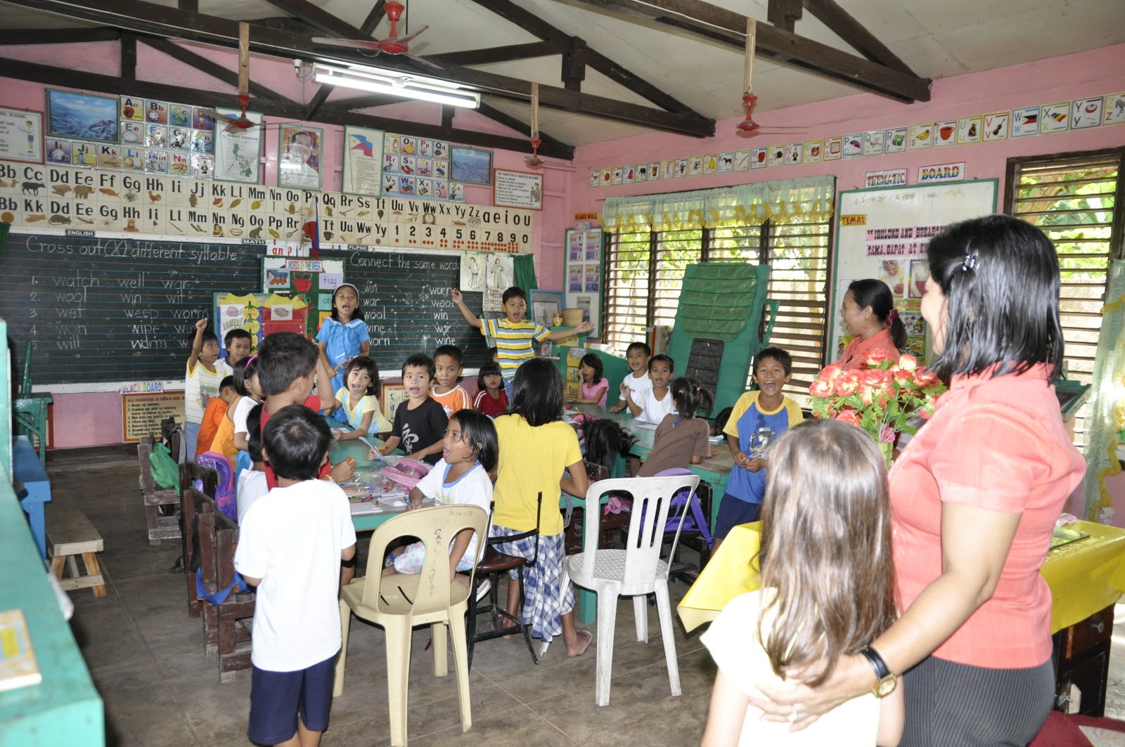
We arrived first thing in the morning, in time to see the flag raising ceremony and national anthem, followed by some unstructured group physical activity (mainly "hokey pokey" type dancing and stretching).  We next went inside the classrooms, grade by grade starting with 4th grade, then 3rd, then 1st, then peeked in the other grade classrooms.  We also got to see the canteen where the children eat, and can purchase some snacks or bread. Since there is no winter in the Philippines and the weather (at least in Mindanao) can be quite hot and humid all year long, the schools are built in an open-air plan with no glass in the windows.  Instead, large vented "grill" windows similar to Venetian blinds span the entire length of the room, bringing fresh breezes into the classroom.   The photos of the elementary we visited are fairly representative of the same style architecture and layout of many of the public elementary schools I've seen in the provinces, small towns, or rural areas of the Philippines. 


The children were all very delightful and proud to show us their classroom, greeting us in unison (in English) and thanking us for coming.  They were particularly happy to interact with our daughter, and they were as honored to have her as a visitor as she was to be their guest.  Like many other school children in the Philippines, some of the children attending this school cannot afford to even buy a single piece of bread for their lunch.  Sadly,  we encountered a bright and smiling little 12-year-old girl, who had only just started first grade.  She had been held back by her parents until this year due to the need to keep her at home so she could help with farming.  Curriculum, books, notebooks, and school supplies are all an economic issue and hardship, not just for the students, but also for the teachers - unfortunately, the necessary items for education do not always make it to the final destination where they are needed most.  This visit truly provided a new perspective for our daughter (and indeed for all of us), helping her to realize how fortunate she is as a student in her public school district in the U.S.   But it also showed her that despite the economic adversity these kids face daily, they are bright, resourceful, kind, caring, delightful, and very much like herself in so many ways.  A great life lesson for a not-quite 8-year-old, and for all of us!


Post-script 03/01/13...    This post has been the most popular so far in terms of all-time views on my website, but oddly enough, it has gotten very few comments in comparison to some of my other posts.  

Preparing to raise the flag
Raising the Philippine flag
Stirring the pot exercise
"Hokey Pokey" morning exercise

Sidewalk between open-air classrooms

First time meeting the 4th grade class

Children greeting our daughter in unison
Children greeting us, responding to teacher

Reciting Philippine Pledge of Allegiance in Tagalog

Boys will be boys


Girls with classroom reading materials

Open-air public elementary school classroom in Philippines


Students with teacher in Philippine public elementary school 

On-site canteen where students get their lunch


Thursday, December 8, 2011

Plantation Bay Resort (Mactan Island, Cebu, Philippines) part 2

To follow up on a previous post, I found some more photos of Plantation Bay on Mactan Island, Cebu, the Philippines.  Mactan Island is very significant in world history, as it is the site of Magellan's defeat and death at the hands of the datu (tribal chief or sultan) Lapu-Lapu. 

I think these photos just further illustrate what a nice, inviting, clean, and relaxing place Plantation Bay is.  On the previous post,  I didn't show photos of their beach front, which is really nice and allows for ample opportunity to swim and collect sea shells.   I also wish that we had taken more photos of the grounds at night time; quite beautiful with all the lights.

Looking for coral and shells at Plantation Bay Resort beach

Beach-combing at Plantation Bay Resort, Mactan Island 

Plantation Bay saltwater pool with island

View of length of saltwater pool

Plantation Bay saltwater pool

Kayaking on saltwater pool

Saltwater pool


Plantation Bay main lobby, night time.  Gorgeous architecture!


Plantation Bay main lobby at night 


LinkWithin

Related Posts Plugin for WordPress, Blogger...